Our Services

Blue Latitudes combines our industry expertise with research-based insights and technical tools to assess offshore infrastructure on a case-by-case basis to determine the best environmental, economic, and socially responsible outcomes available for our clients.

ROV_subsea equipment.PNG

rov-based environmental surveys 

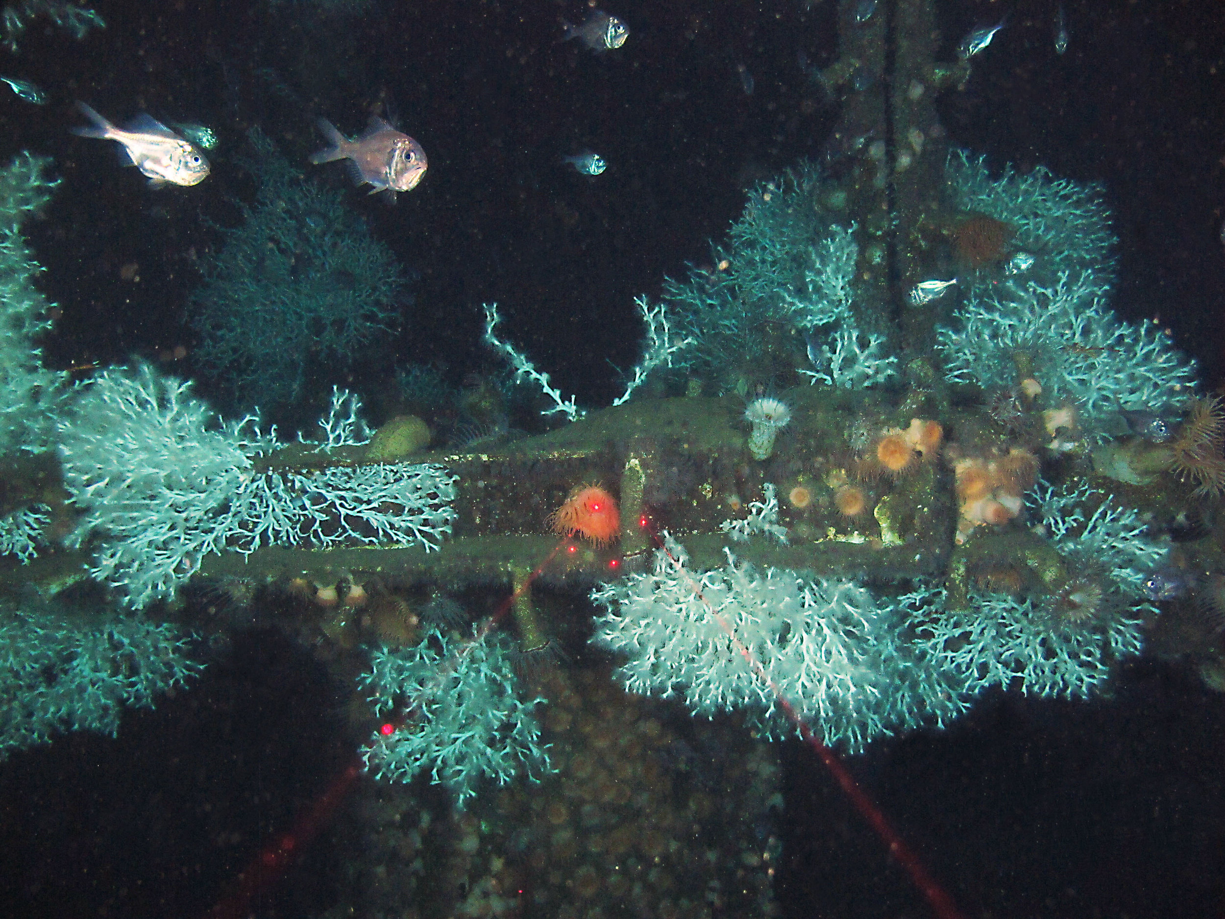
We design and deploy marine life surveys using remotely operated vehicles (ROVs) to evaluate ecological biodiversity and abundance on offshore infrastructure, including subsea equipment.

hydroacoustic Fish surveys

We design and deploy hydroacoustic surveys to monitor fish movements over large scale environments and determine fish abundances on offshore infrastructure utilizing sound movements through water, this is especially valuable as a tool to sample highly mobile species.

Copyright_CDelacy_2014.jpg

Environmental impact assessments 

We develop technical environmental assessment reports to describe the ecological value associated with offshore structures and conduct field studies, as needed, to support these projects.
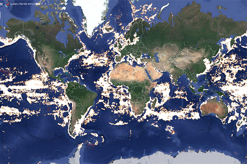
global fishing watch.png

Fisheries analysis

We leverage our tool FishLAT to quantify how fishery stakeholders interact with offshore structures, identify potential impacts, and present solutions that lessen the frequency of negative interactions between ocean stakeholders.

oil rig.jpg

permitting & Regulatory compliance 

We prepare environmental documents for permit compliance. Our services are particularly valuable where independent technical support, re-analysis of existing data, or additional studies are needed. These services often yield significant cost savings for our clients.

IMG_3799.JPG

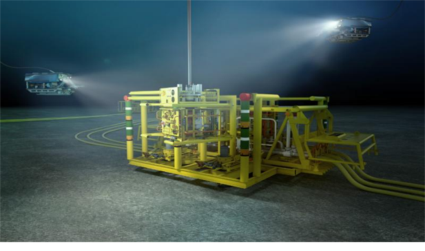
DECOMMISSIONING planning& Siting studies

We identify sites for reefing and support our clients in navigating the complexities of planning for decommissioning to ensure that all planned cleanup actions comply with environmental standards, align with stakeholder considerations, and satisfy required permits and regulations.

marine research.jpg

marine life surveyS on oil & gas platforms

We evaluate the marine ecosystems found on platforms and subsea equipment to assess if a structure is a viable candidate for a Rigs to Reefs conversion or a leave-in-place decommissioning strategy.

CA%25252Brigs%25252Band%25252BMPAs_BigPicture%25252B%252525281%25252529.jpg

GIS Analysis & Mapping Technologies

We are uniquely qualified in geographic information systems (GIS), combining both data science and storytelling, to use spatial analytics to visualize ecological processes and craft compelling, data-driven narratives for stakeholders across technical and non-technical audiences.

Scripps Pier KPBS.jpg

public outreach & communications

We relate complex scientific ideas to a broad demographic of audiences across multiple platforms, including major news outlets, social media, lectures, publications, and film.

Global Project Experience


Blue Latitudes has conducted a variety of projects all over the world, including the Gulf of Mexico, California, Mauritania, Malaysia and the North Sea.


Artificial Reef Planning with FishLAT

Gulf of Mexico, USA

Blue Latitudes provided planning and siting support to select 40 future artificial reef sites out of a pool of 900 candidates located throughout coastal Louisiana. Utilizing FishLAT, Blue Latitudes conducted a suitability ranking for each potential site; by evaluating various factors such as opportunities for commercial and recreational fishing, fish habitat value, and logistical feasibility. This ranking system provided a clear categorical hierarchy of the most suitable sites for artificial reefing, streamlining the decision-making process for the client and artificial reefing agency involved.

Permitting Support: Special Artificial Reef

Gulf of Mexico, USA

Blue Latitudes provided permitting support to decommission and reef South Timbalier 206A and incorporate it into Louisiana’s Artificial Reef Program as a Special Artificial Reef Site (SARS). Blue Latitudes designed a ROV survey to evaluate the marine life and analyzed recreational and commercial fishing activity at the site to better understand the structure’s value to fisheries stakeholders. The findings demonstrated that the South Timbalier 206A platform is biologically significant and met the criteria required for SARS candidates.

Beta Field Marine Environmental Services

Blue Latitudes provided marine environmental services to assist Amplify Energy in evaluating future options for decommissioning its assets within the Beta Field, offshore of Huntington Beach, California. One strategy was in-situ reefing via a Rigs to Reefs conversion. Blue Latitudes conducted a series of environmental studies including a literature review, an analysis of archived ROV maintenance footage, an evaluation of fishing patterns, and a ROV-based marine life survey assessment of the platforms. Cumulatively, the findings from these studies served to help Amplify identify opportunities and constraints associated with converting their platforms into permanent artificial reefs.

unsplash-image-YV593oyMKmo.jpg

Marine Life Survey:

Oil & Gas Platforms

Blue Latitudes designed, developed, and executed ROV-based marine life surveys on PETRONAS’s platforms to assess species richness and abundance of corals, fish, and invertebrates. These surveys were one of the first comprehensive ecological assessments to use a ROV to describe the marine life assemblages found on platforms in the South China Sea. The results were summarized in both a manuscript and a stakeholder engagement video to demonstrate how ROV-based marine life surveys could be used to validate the platform suitability rankings produced by PETRONAS’s Reefing Viability Index.

Gunnison spar.jpg

Environmental Services: Spar Decommissioning

Anadarko sought environmental support services from Blue Latitudes to decommission a spar in the Gulf of Mexico. Blue Latitudes provided the technical studies to support the designation of a reefing location for a spar hull facility. Additionally, Blue Latitudes supported Anadarko in evaluating opportunities to abandon in-situ several subsea legacy components that were part of the spar’s subsea production field. The spar facility is the third spar to ever be decommissioned in the world, and only the second spar to be considered as a reefing candidate. As a result, selecting a suitable reefing site was an iterative process, requiring close coordination with regulators to facilitate reefing plans and required permits.

Lophelia.jpg

Marine Life Survey: Subsea Equipment

Blue Latitudes managed and designed a marine life survey using a remotely operated vehicle (ROV) equipped with video to evaluate ecological biodiversity and abundance on a subsea template and associated wells located in approximately 970 ft of water in the Garden Banks region of the Gulf of Mexico. This survey was integrated into plug and abandonment efforts to minimize vessel cost. Additionally, apparent commercial and recreational fishing activity in the area surrounding the site was evaluated. All ROV marine life and fishing activity data into a report that was presented to the United States Navy and Bureau of Safety and Environmental Enforcement. The project resulted in the first subsea equipment permitted in-situ at a depth shallower than 1,000 ft.

s.jpg

Fisheries Assessment

Blue Latitudes assessed apparent commercial and recreational fishing activity in the vicinity of two subsea wellheads in approximately 900 ft of water in the Gulf of Mexico. The purpose of this evaluation was to ensure that if the wells were reefed in place, then there would not be a significant space use conflict arising from multiple interested parties competing for a finite, spatially bound resource. Blue Latitudes cataloged and formalized all the fishing activity data into a report to satisfy the concerns of the US Navy and BSEE. Blue Latitudes’ assessment was critical in successfully acquiring the permit to decommission the wellheads in place.

Ecological Review using Historic ROV Footage

Blue Latitudes conducted an ecological review of the benthic marine life associated with deep-sea pipelines and associated subsea hardware using historical ROV inspection footage. This ecological review was used to establish a baseline understanding of the localized marine environment and expand upon the findings from Marine Life Surveys designed by Blue Latitudes to determine marine life colonization and growth rates at the site.

Mauritania.jpg

Offshore Oil Field Decommissioning in Mauritania

The Chinguetti oil field, operated by Petronas Carigali, has been in operation for over 10 years. In anticipation of the decommissioning of the system, Petronas Carigali proposed an Abandonment and Decommissioning Plan (A&DP) and an Environmental Impact Study (EIS) for the field and its associated production equipment to the Government of Mauritania (GOM). To guide the GOM in approving its first ever A&DP, Blue Latitudes conducted an environmental review of the A&DP and EIS. In the review of the A&DP and EIS, Blue Latitudes analyzed international regulations and industry best practices to advise Mauritania’s Ministry of Petroleum on environmental considerations when designing a decommissioning operational plan. Blue Latitudes’ efforts in assisting the GOM to decommission the Chinguetti oil field in a sustainable manner set a precedent for successful future decommissioning projects in Mauritania

IMG_3799.JPG

ROV Marine Life Survey & Ecological Assessment of L. pertusa

Blue Latitudes designed ROV-based marine life surveys on the Amberjack and Pompano platforms to develop a baseline understanding of the marine life associated with the two platforms, including fish community structure and percent cover of the cold-water coral Lophelia pertusa. The ecological assessment provided potential corroborating baseline data to support future decommissioning decisions, and ultimately will help determine if in-situ decommissioning may equal or surpass the level of environmental protection required by federal and state agencies, when compared to the option of complete removal.

Barracuda.jpg

ROV Marine Life Survey: Post-Reefing

Blue Latitudes managed, designed and lead pre- and post-reefing ROV surveys on the East Breaks 110 offshore oil platform. The purpose of the pre-reefing survey was to support the client’s initiatives to reef the platform structure via the partial removal method by evaluating the ecological biodiversity and abundance associated with the platform structure. The objective of the post-reefing surveys was to evaluate the rates of biological recruitment and colonization on the reefed structure and to provide corroborating evidence to support the claim that the partial removal method of reefing may have a beneficial environmental impact.

Doug-Aitken.-Underwater-Pavilions.-Pacific-Ocean-Catalina-Island-postinterface-091216.jpg

Pavilions at Catalina Island Dive Park

The Catalina Island Underwater Pavilions is artist Doug Aitken’s large-scale installation produced by Parley for the Oceans. The work consists of three temporary underwater sculptures, floating beneath the ocean’s surface. Blue Latitudes managed and provided a written biological assessment depicting the proposed site for the Pavilions sculpture park off Catalina Island. The written assessment included a description of the habitat types as well as the available Essential Fish Habitat found around the proposed installation area. Blue Latitudes also provided an assessment for the potential presence of abalone species, including the suitable habitat for black abalone.

gallery_medium.jpg

Pre-Proposal Support

Blue Latitudes provided environmental and permitting support to Malibu Oyster Company for the development of a pre-proposal to pursue a California state bottom lease for growing premium oysters for the half shell market, as well as fresh kelp for consumption (the Project). The primary research priority of this Project was to identify the regulatory constraints and challenges to oyster farming in the state of California and identify ways to make the aquaculture permitting process more efficient while still maintaining compliance with regulatory mandates and statutory requirements. The secondary research priority of this Project will be to improve regional oyster farm planning. Blue Latitudes provided Malibu Oyster Company with the necessary permitting and regulatory guidance pertaining to the California Environmental Quality Act (CEQA), long-range planning support, and a communications strategy, which was incorporated into the final pre-proposal application submittal.

Frequently Asked Questions


Do the platforms corrode, and thus prove unstable?

Offshore oil and gas platforms are made of various types of steel including carbon, stainless, high strength low alloy, and weathering, which over time corrode, due to the highly corrosive nature of the ocean (MetalsUSA 2024). 

In a 2004 study, Love and Schroeder describe the sacrificial anodes, constructed of aluminum or zinc, that are used to safeguard against corrosion on operational oil and gas platforms.  These anodes  work by oxidizing more quickly than the steel of the platform jacket they are protecting, ensuring the structural integrity and longevity of the platforms. This cathodic protection typically endures for several decades as long as the anodes remain intact. Once a platform is reefed, it's assumed that there won't be any further replacement of sacrificial anodes, although this issue remains unaddressed for California platforms. While corrosion rates in seawater fluctuate based on factors such as water temperature and biofouling, it is estimated that the life span of a cathodically unprotected platform will range from a minimum of 100 to more than 300 years (Love and Schroeder 2004; Quigel and Thorton 1989; Mishael S J. Platform decommissioning corrosion estimate, Chevron Corporation, Unpublished Report,1997).


DO REEFED PLATFORMS POLLUTE THE SURROUNDING ENVIRONMENT?

Pollution around California’s platforms has been studied since the late 1970s. In a study published in 1976, Bascom and colleagues (Bascom et al. 1976) assessed pollution levels around oil platforms in the Santa Barbara Channel, by measuring trace metals such as cadmium, chromium, copper, lead, molybdenum, nickel, silver, vanadium, and zinc in the water near the platforms and the surrounding environment.

Their findings indicated that the levels of most trace metals were similar at both control sites (without platforms) and impact sites (with platforms), with the exception of vanadium, which was slightly higher near the platforms, but still did not occur at harmful levels. The researchers also found no unusual levels of hexane extractable materials, volatile solids, copper, or zinc near the platforms.

With regards to hydrocarbon levels, the researchers discovered that mussels and crabs collected from various locations near the platforms didn't contain any detectable amounts of hydrocarbons. This is notable because mussels typically  absorb petroleum hydrocarbons, yet there were no detectable levels found in their tissue.

Love et al. 2004 discuss a different way to gauge potential contamination, drawing from information provided by the California Department of Health Services. For over ten years, the California Department of Health Services has monitored toxin levels in mussels found on platforms. These mussels are harvested in large quantities and sold to restaurants in southern California for human consumption.

According to a state health official quoted in the LA Times, mussels residing on platforms in the Southern California Bight have ‘‘probably the highest quality of shellfish meat sold in California and may be the entire country’’ (LA Times 1994). This superior quality could be attributed to the offshore location of the platforms, which keeps them away from the pollution often associated with agricultural and urban runoff found in nearshore environments.


HOW WILL IMPLEMENTING RIGS-TO-REEFS AFFECT COMMERCIAL FISHING?

Wayne Kotow, President of California’s Coastal Conservancy Association, states that “implementing Rigs to Reefs won't affect current commercial fishing as they have been working around them for years. If anything, they benefit from the habitat and ecosystems that aggregate and expand biomass. Think of it as a benefit from the spillover effect.” 


What is the establishment and maintenance costs for R2R?

In the Gulf of Mexico, where reefed platforms transition into the responsibility of the state, ongoing maintenance and operations for reefing programs, including Rigs to Reefs conversion and other artificial reefs, entail significant expenditures. States such as Louisiana allocate approximately $5-8 million annually to monitor and maintain over 400 converted platforms along its coastline, as well as other artificial reefs (LDWF 2019).


How do Reefed structures function as fish habitat?

After 30 years of observing and monitoring the marine ecosystems on oil platforms, research has suggested that these structures have evolved into economically and ecologically valuable ecosystems. For example, juvenile rockfish, several species of which are currently recognized as being overfished in the state of California, have been found to live in higher densities at several of the platforms as compared to nearby natural reefs. “In some locations, platforms may provide much or all of the adult fishes of some heavily-fished species and thus contribute disproportionately to those species larval production”(Love et al. 2003).  


Researchers suggest three reasons for the finding: (1), platforms physically occupy more of the water-column than most natural outcrops; (2), because there are fewer large fish in the mid-water habitat where the platforms are located, predation is likely lower; and (3), the location and size of offshore platforms “provide great delivery rates of planktonic food for young fishes”(Love et al. 2003). 


WHAT IS THE OLDEST KNOWN RIGS TO REEFS CONVERSION?

In Louisiana, the Department of Wildlife and Fisheries has been running a Rigs to Reefs program for more than 30 years. This initiative repurposes oil and gas platforms to serve as habitats in Louisiana's artificial reef program (Kasprzak 1998). The oldest known rigs to reefs conversion took place over forty years ago in Florida in 1979 with the relocation of an Exxon experimental subsea template from offshore Louisiana to a permitted artificial reef site off Florida (GulfBase 2024).